Rules and Regulations for Drone Usage in Monte Albán
Quick answer for drone pilots
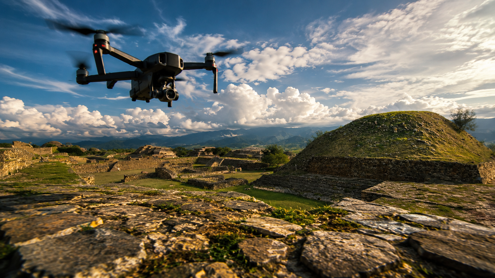
Do not fly a drone in, over, near, or visually connected to Monte Albán until you receive direct written confirmation from INAH. Monte Albán is not simply a scenic viewpoint. It is a protected archaeological zone under the care of Mexico’s Instituto Nacional de Antropología e Historia, known as INAH.
The safest practical recommendation is to wait for written authorization before any drone activity. This is especially important if the proposed flight could be inside the archaeological zone, above the visitor area, near the site boundary, or within the broader protection polygon associated with Monte Albán.
| Question | Practical answer |
|---|---|
| Can I fly a drone freely at Monte Albán? | No. Drone use should be treated as restricted and subject to INAH review. |
| Is there a public INAH no-fly map with coordinates? | No public INAH map with drone-specific coordinates was located. |
| Does that mean drones are allowed? | No. The absence of a public coordinate map does not mean free flight is permitted. |
| What should I do first? | Contact INAH and use the official INAH-01-001 process when professional or special equipment is involved. |
Why drone use is sensitive at Monte Albán
Monte Albán is one of Oaxaca’s most important archaeological landscapes. The protected area is broader than the main plaza, platforms, ball court, museum, and visitor route. INAH sources describe Monte Albán as part of a larger cultural landscape connected with surrounding hills and areas such as Atzompa and Cerro del Gallo.
This matters because a flight that appears to be outside the tourist circuit may still be near or within a sensitive heritage area. Drone noise, aircraft movement, filming angles, visitor safety, and the public use of images can all be relevant. For this reason, a drone flight should never be treated as a casual travel activity at Monte Albán.
Main INAH permit for professional equipment
The main INAH procedure is INAH-01-001. This is the official process for authorization of photography, filming, or videorecording in archaeological zones, monuments, and museums when special or professional equipment is used. Drone work connected to professional filming, commercial photography, documentary production, media coverage, promotional content, mapping, or public distribution should be reviewed through this formal channel.
- Procedure name: INAH-01-001.
- Applies to: Photography, filming, or videorecording with special or professional equipment.
- Where it applies: Archaeological zones, museums, monuments, and heritage sites under INAH custody.
- Minimum lead time: Start the request at least 10 business days before the planned shoot.
- Published response time: 3 business days.
- Permit duration: Equal to the duration of the approved project.
Approval is not automatic. INAH evaluates whether the activity could affect the integrity of the cultural heritage or distort its image. Even when a project is well organized, INAH may impose conditions, ask for changes, or deny drone use.
Current INAH fees for 2026
For 2026, INAH publishes the following fees for the INAH-01-001 procedure. These fees apply to authorized professional photography, filming, or videography in a zone, museum, or monument under the custody of the competent institutes.
| Activity | Published 2026 fee | Important note |
|---|---|---|
| Filming or videography | $15,916.00 MXN per day | Payment is connected to the authorization and does not guarantee drone approval by itself. |
| Photography | $7,958.00 MXN per day | Professional or special equipment may require prior authorization. |
These amounts are official INAH fees for the covered activity. They should not be understood as a drone ticket, drone license, or automatic flight permission. A drone still requires specific review and written authorization when INAH considers it relevant to the project.
What the INAH record shows about drones
The most important practical detail is that INAH has previously denied drone image capture in a Monte Albán related filming request. A 2019 INAH transparency record concerning filming at the Archaeological Monuments of Monte Albán and the Museum of the Cultures of Oaxaca stated that image capture with drones was not authorized in that case.
- Drone use may be denied, even when a broader filming request is being considered.
- Heavy equipment may be restricted, especially on or near cultural property.
- Each request is reviewed case by case, based on location, purpose, equipment, and heritage protection concerns.
- Written approval is essential, because informal assumptions can create legal and conservation problems.
In simple terms: Monte Albán is not a place to test a drone, improvise a shot, or rely on general internet advice. The correct route is to ask INAH directly before flying.
The protection polygon and nearby areas
INAH sources refer to a broader protection polygon connected with Monte Albán. This protected area is not limited to the main visitor route. It includes a larger archaeological setting associated with the hills and nearby areas that form part of the cultural landscape.
| Area or concept | Why it matters for drone use |
|---|---|
| Monte Albán visitor area | The main archaeological zone is highly sensitive and should not be flown over without written INAH authorization. |
| Protection polygon | A proposed flight near the site may still fall within or affect a protected heritage area. |
| Atzompa and Cerro del Gallo | These areas are connected to the broader archaeological landscape described by INAH. |
| Nearby communities and hillsides | Flights around Monte Albán can still raise heritage, safety, and visual impact concerns. |
Because INAH has not published an easily accessible drone perimeter with coordinates for Monte Albán, applicants should contact the site administration and the Área Jurídica y Polígono de Protección. This is the best way to clarify whether a proposed location, route, or filming angle creates a problem.
Aviation rules also apply
INAH authorization is only one part of responsible drone operation. Drone pilots must also comply with Mexican aviation requirements issued by the competent aviation authority. The Agencia Federal de Aviación Civil, known as AFAC, publishes information for RPAS, or remotely piloted aircraft systems.
- INAH permission addresses heritage, site, museum, image, and cultural protection concerns.
- Aviation compliance addresses airspace, aircraft operation, safety, registration, and pilot responsibility.
- Both may be needed for a legal and responsible drone operation near Monte Albán.
Aviation compliance does not replace INAH authorization, and INAH authorization does not replace aviation compliance. A careful pilot should review both before planning any flight.
Official contacts for forms and questions
For the safest answer, contact INAH directly and request written guidance. The following contacts are the most relevant for questions about Monte Albán, the protection polygon, forms, and professional filming or photography requests.
| Office or area | Contact | Best for |
|---|---|---|
| Dirección de la Zona Arqueológica y Museo de Sitio de Monte Albán | David Andrade Olvera david_andrade@inah.gob.mx +52 (951) 516 7077 | Questions about the archaeological zone, museum, access, and site-level guidance. |
| Área Jurídica y Polígono de Protección | Carolina Valentín Contreras carolina_valentin@inah.gob.mx +52 (951) 501 2311 | Questions about legal review, boundary concerns, and the protection polygon. |
| Centro INAH Oaxaca | José Manuel Bañuelos Ledesma josemanuel_banuelos@inah.gob.mx +52 (951) 515 0389 +52 (951) 515 0400 +52 (951) 515 0002 | Broader institutional questions, filings, and follow-up with INAH in Oaxaca. |
Best practice checklist before any proposed flight
Before planning any drone activity connected to Monte Albán, use this checklist as a practical starting point. It does not replace official authorization, but it can help organize your request and avoid common mistakes.
- Do not fly first and ask later. Wait for written INAH confirmation.
- Use the INAH-01-001 form when special or professional photography, filming, or videography equipment is involved.
- Apply at least 10 business days in advance, and allow extra time for clarification.
- Describe the project clearly, including purpose, dates, crew, equipment, locations, and how the images will be used.
- Ask about the protection polygon if the flight is near, around, above, or visually related to Monte Albán.
- Confirm aviation obligations with the current Mexican drone rules that apply to RPAS operations.
- Keep written authorization with you during any approved work.
Monte Albán has watched over the Valley of Oaxaca for centuries. Protecting it means more than following a checklist. It means recognizing that every image, flight, and production decision should respect the ancient city, the communities around it, and the institutions responsible for its conservation.


