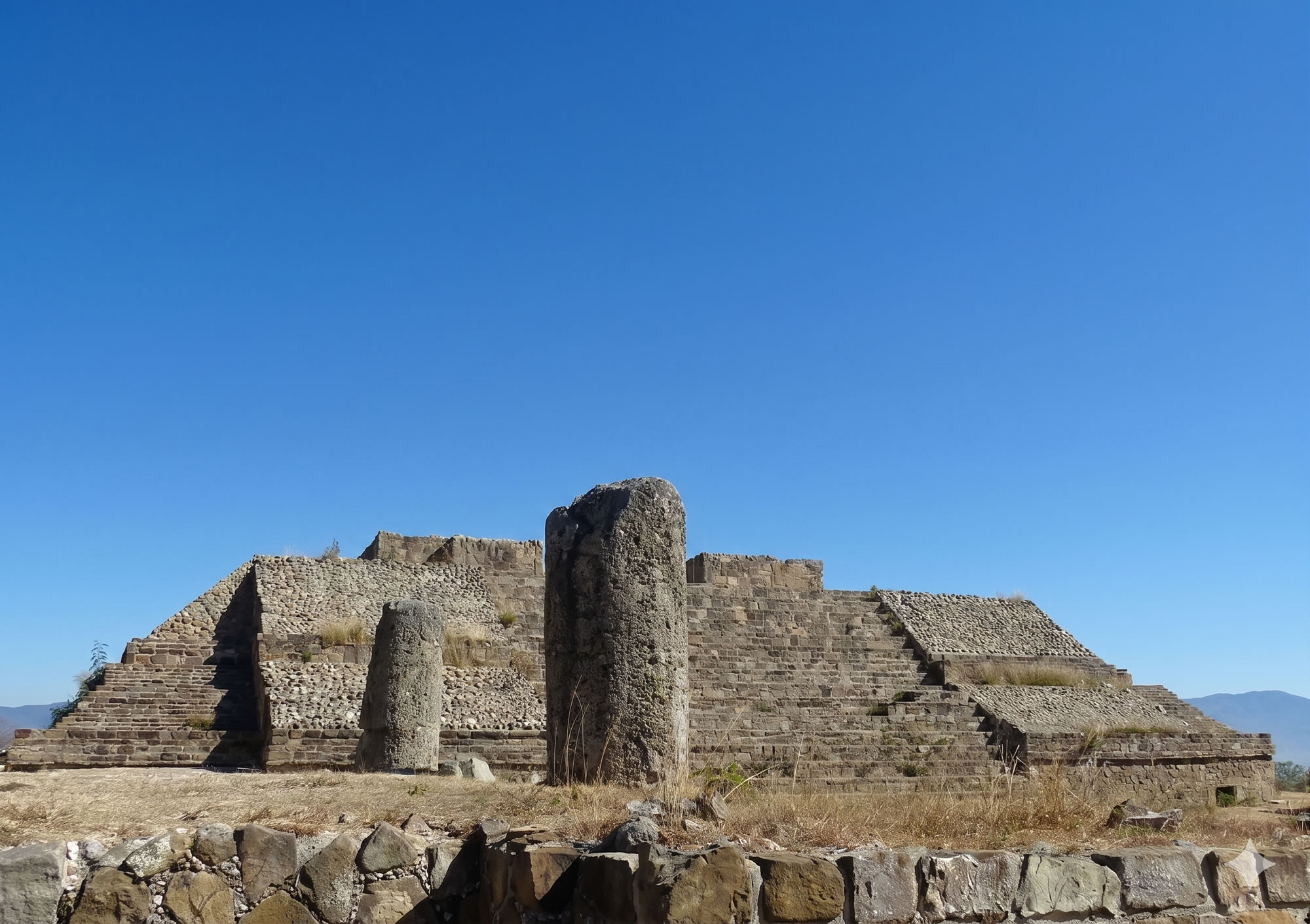
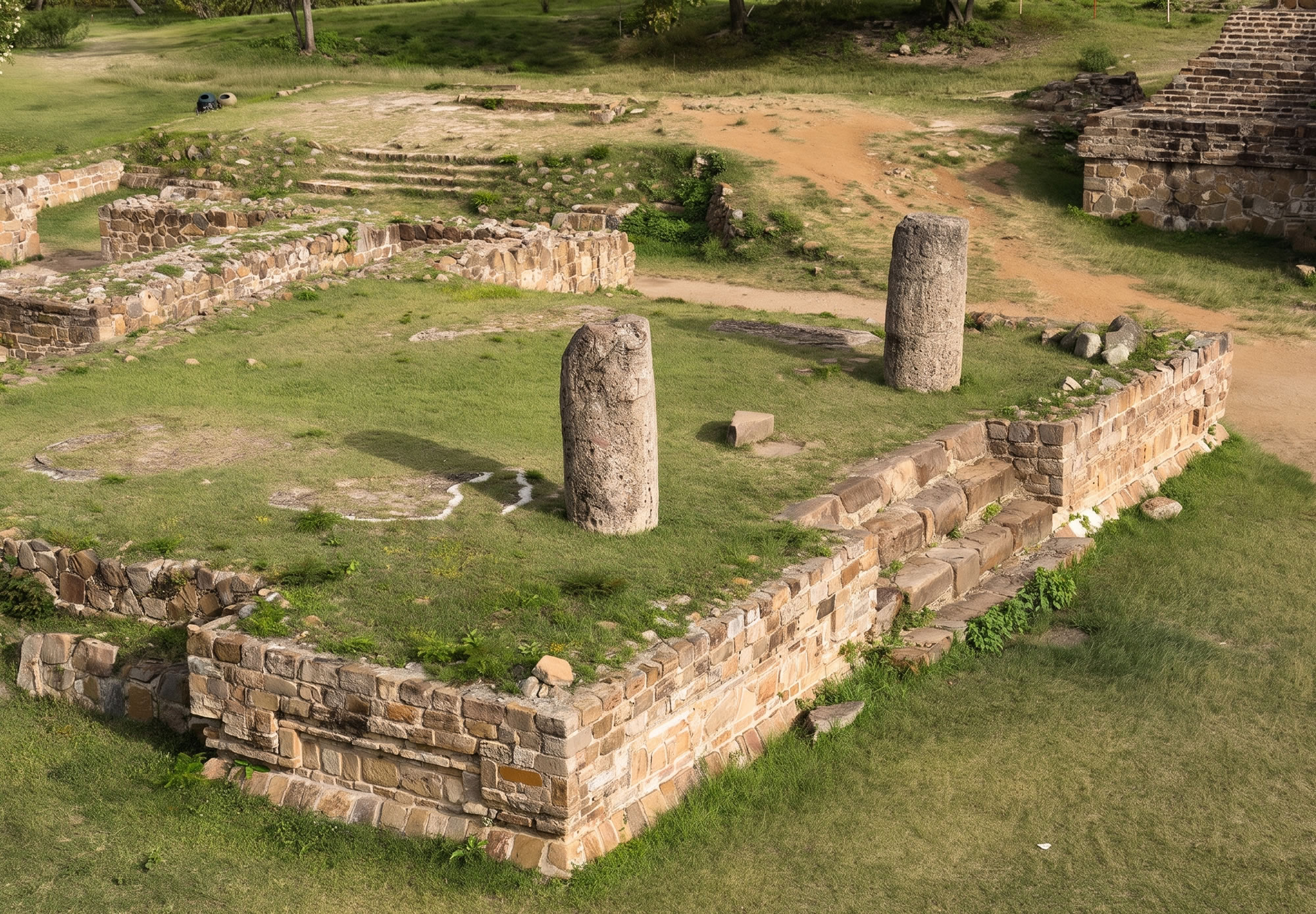
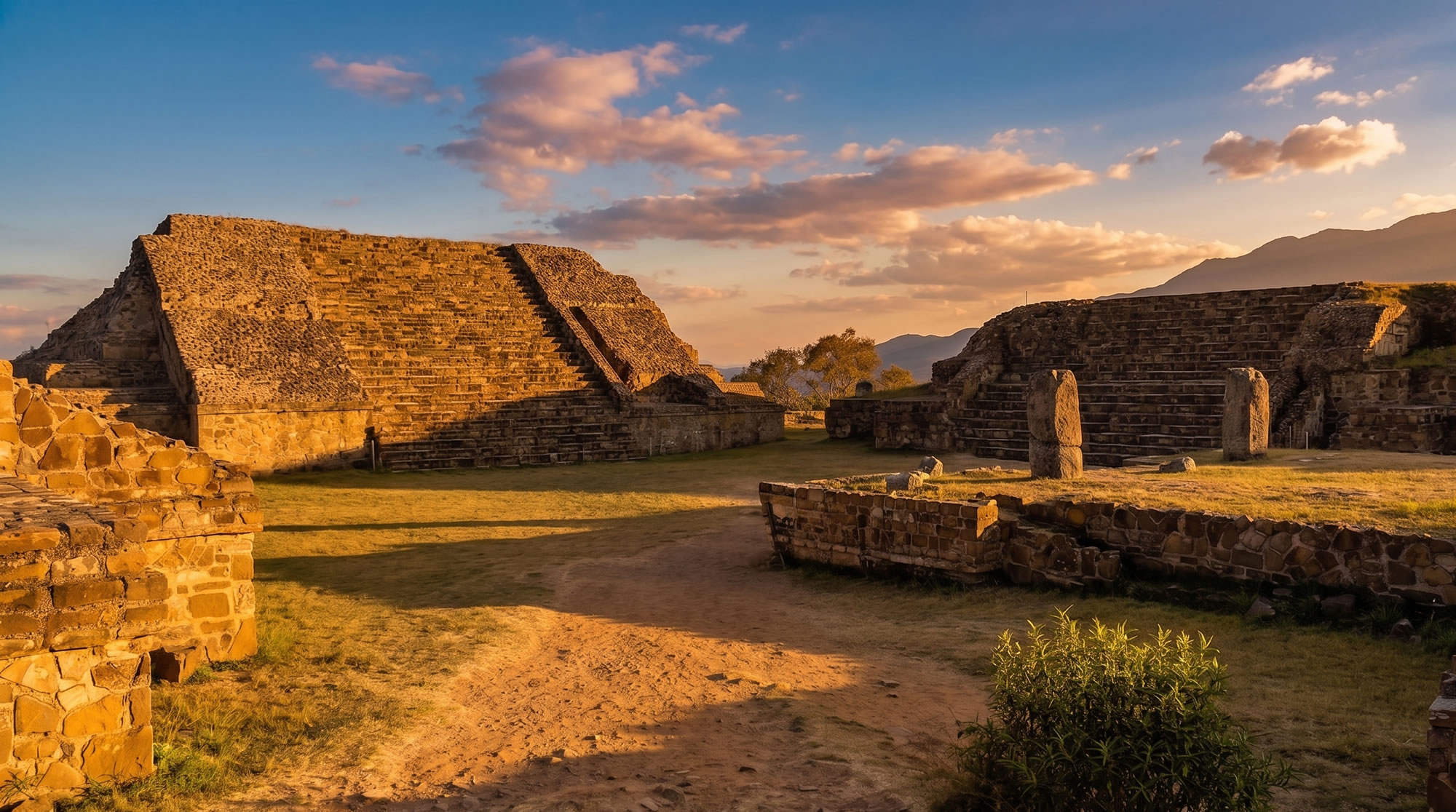
The Temple of the Two Columns, located within the Conjunto Vértice Geodésico on the summit of Monte Albán's North Platform, belongs to one of the most restricted and intellectually sophisticated ritual environments known from the Zapotec capital. The complex sits at the northernmost high point of the great acropolis and is organized around a small quadrangular precinct that includes Building VG on the east, the Temple of the Two Columns on the west, Building D on the north, and Building E on the south. INAH's public site map identifies the Conjunto Vértice Geodésico, Building VG, Building D, Building E, and the surrounding North Platform structures as part of the official Monte Albán visitor layout.1
Its importance is not simply architectural. The Temple of the Two Columns and Building VG form an observational pair. From the stair zone of Building VG, the setting sun can be observed toward the Temple of the Two Columns on dates that INAH has described as relevant to pre-Hispanic calendrical practice, especially September 1 and April 11.2 In that sense, this small summit complex was not merely a ceremonial patio. It was a built calendar, a restricted ritual stage, and a statement of elite control over sacred time.
The North Platform: Spatial Hierarchy and the Mountain of Creation
The North Platform was the dominant elite zone of Monte Albán. Rising above the Main Plaza, it expressed political hierarchy through elevation, mass, and controlled access. UNESCO describes Monte Albán as a sacred topography literally carved out of the mountain through terraces, dams, canals, pyramids, and artificial mounds.3 That observation matters because the North Platform was not simply placed on a hill. It was part of the transformation of the hill itself into a monumental political and ritual landscape.
Within this built mountain, the Conjunto Vértice Geodésico occupied the most elevated and restricted symbolic position. The great staircase of the North Platform created a powerful ceremonial transition between the public theater of the Main Plaza below and the elite precincts above. The higher a visitor climbed, the more private and politically charged the architecture became. By the time one reached the Geodesic Vertex Complex, the setting was no longer public urban space. It was an enclosed summit environment for restricted ritual activity.
The Acropolis as Political Theater
The North Platform should be read as both architecture and message. Its elevation separated rulers from the population physically, while its ceremonial spaces allowed elite groups to present themselves as guardians of the calendar, rainfall, dynastic continuity, and cosmic order.
The Conjunto Vértice Geodésico: Architecture of Restricted Ritual
The modern name Conjunto Vértice Geodésico comes from a later topographic reference marker, not from the ancient Zapotec name of the precinct. Its ancient function, however, appears to have centered on restricted ceremony, high-status architecture, and solar observation. The complex is arranged as a quadrangle around a small patio, producing a controlled spatial container in which sightlines, movement, and access could be carefully managed.
| Structure | Position in Complex | Primary Construction Context | Probable Function |
|---|---|---|---|
| Temple of the Two Columns | West side | Monte Albán IIIB-IV | Solar marker, ritual temple, and western focus of the VG axis |
| Building VG | East side | Monte Albán IIIB-IV | Observation platform and high-status ritual structure |
| Building D | North side | Monte Albán IIIB-IV | Temple support structure within the enclosed summit precinct |
| Building E | South side | Monte Albán IIIB-IV | Ceremonial platform within the quadrangle |
The architectural language of the complex belongs to the mature Zapotec state tradition: stone foundations, adobe superstructures, stuccoed surfaces, platforms, stairways, and formal talud-tablero compositions. INAH identifies nearby elite North Platform buildings with decorative tablero and escapulario elements, including the double-scapular motif associated with Oaxaca's monumental architecture.4 These formal choices were not ornamental filler. They made the precinct legible as elite space.
Geospatial Location
Structural Analysis of the Temple of the Two Columns
The Temple of the Two Columns is the western architectural focus of the VG observational axis. Its defining feature is the pair of massive columns that marked the vestibule and gave the building its modern descriptive name. INAH's description of a related North Platform structure notes a temple divided into two clearly defined spaces: a large vestibule delimited by two columns and the temple proper set approximately 15 centimeters higher.5 This same spatial grammar is essential for understanding the Temple of the Two Columns as more than a platform with pillars. It was a sequenced ritual building.
Internal Division and Sacred Planes
The temple plan separates preparation from encounter. The vestibule, framed by the two columns, functioned as an intermediate zone. The slightly higher interior room, or cella, marked a more restricted sacred plane. The elevation difference was small in engineering terms, but significant in ceremonial terms. Ancient architecture often used modest changes in height, threshold, and enclosure to communicate transitions in ritual status.
The interior chamber was rectangular, accessed through a narrow opening, and did not repeat the columned plan of the vestibule. Stone foundations supported walls likely made of adobe, while timber beams and earthen roofing would have completed the superstructure. The perishable elements are gone, but the surviving stone courses preserve the footprint of an architectural volume designed for controlled entry, framed vision, and staged movement.
Monolithic Columns and Non-Local Stone
The two columns were not casual supports. Their size, material presence, and placement made them visual anchors for the west side of the complex. The source tradition records the columns as approximately 2 meters in diameter and associated with a roof that may have stood approximately 6 meters above the platform floor. It also notes that the stone was non-local, implying transport from beyond the immediate hill. That logistical decision deserves attention. Moving large stone elements up Monte Albán's steep summit was not just labor. It was political theater turned into masonry.
Non-local monoliths at a summit sanctuary would have carried meaning beyond engineering. They connected the precinct to wider Zapotec territory, resource control, ritual geography, and possibly sacred quarries. The physical act of hauling stone uphill made the building a statement of organized power. The columns were therefore structural, symbolic, and territorial at the same time.
Iconography of the Wide-Beaked Bird Deity
The columns are associated in the source tradition with bas-relief images of the deity commonly described as the God of the Wide-Beaked Bird, or Dios del Pico Ancho. This bird-like figure belongs to the broader Zapotec religious world in which deities, ancestors, sky forces, rain, maize, and elite funerary imagery were deeply connected. INAH's descriptions of Monte Albán tomb art and urn imagery repeatedly show how elite ritual contexts incorporated deities, animal attributes, calendrical signs, and ancestor imagery.6
The placement of a sky-related bird deity at the entrance to a solar observation precinct is not accidental in interpretive terms. The bird marks the threshold between human architecture and the sky. In this context, the deity can be read as a symbolic guardian of the solar frame: the entrance through which sacred time was observed, confirmed, and ritually activated.
Interpretive Caution
The deity's exact Zapotec name and full theological role remain matters of specialist interpretation. What can be stated responsibly is that the iconography links the temple to elite ritual, celestial symbolism, and the wider visual language of Zapotec sacred power.
Building VG: The Eastern Axis and Ritual Interments
Building VG stands directly across the patio from the Temple of the Two Columns and forms the eastern anchor of the observational axis. During INAH's September 1, 2025 archaeoastronomy workshop, archaeoastronomer Aarón Uriel González Benítez positioned participants at the beginning of Building VG's stairway, facing the Temple of the Two Columns, so they could observe the sunset disappearing between the columns.13 This field demonstration is especially important because it ties the modern observation directly to the architectural relationship between Building VG, the enclosed patio, the Temple of the Two Columns, and the western horizon.
The source text also records that excavations in Building VG revealed a significant tomb with high-value offerings, including pearls, marine shells, and polished greenstone. Such materials would link a summit sanctuary to long-distance exchange and to symbolic concepts of water, fertility, the sea, and ancestral power. In Mesoamerican thought, mountains and watery origins were not opposites. They were often conceptually intertwined as sources of life, rain, caves, clouds, and maize.
If elite individuals were interred in the same structure used for solar observation, the implication is powerful: dynastic ancestors were anchored into the architecture of time. The rulers who watched the calendar from the summit were not alone. Their dead were part of the ritual machinery.
Archaeoastronomical Significance: The Built Solar Calendar
The strongest documented public evidence for the VG complex's solar role comes from INAH's 2025 report on the workshop "Introducción a la arqueoastronomía de Monte Albán." INAH states that the VG architectural complex contains different solar alignments and cites Ivan Šprajc's observation that one alignment occurs when the axis of symmetry of the building aligns with sunset on September 1 and April 11.2
During that same event, archaeoastronomer Aarón Uriel González Benítez placed participants at the beginning of Building VG's stairway, facing the Temple of the Two Columns, so they could observe the sun disappearing between the columns. INAH also includes an important caution: the columns may have experienced alterations relative to their original position, although the dates shown by the alignment still correspond to relevant moments in pre-Hispanic calendrical thought.13
| Observational Target | Event | Primary Date | Secondary Date | Calendrical Meaning |
|---|---|---|---|---|
| Temple of the Two Columns | Sunset framed from Building VG | September 1 | April 11 | Dates associated with the VG solar alignment reported by INAH and Šprajc |
| Western horizon from VG axis | Sunset | September 1 | April 11 or April 12 depending on measurement model | Seasonal division linked to agricultural and ritual scheduling |
| Eastern horizon models | Sunrise reference | March 1 | October 12 | Part of broader observational-calendar analysis in Mesoamerican archaeoastronomy |
Aarón Uriel González Benítez and the 2025 Public Observation
A key contemporary contribution to the public understanding of the Temple of the Two Columns came from archaeoastronomer Aarón Uriel González Benítez during the September 1, 2025 workshop "Introducción a la arqueoastronomía de Monte Albán," held at the Monte Albán Archaeological Zone. INAH identifies González Benítez as a workshop leader and archaeoastronomer certified as a trainer before Mexico's Secretaría de Turismo, and reports that he positioned the participating group at the beginning of the stairways of Building VG, directing their gaze toward the Temple of the Two Columns in order to observe the sun setting between them.13
His contribution is important because it connects the technical archaeoastronomical interpretation of the VG axis with direct field observation. The alignment is not only a theoretical measurement on a plan. It can be demonstrated from a specific viewing position within the complex, using the actual relationship between Building VG, the enclosed patio, the Temple of the Two Columns, and the western horizon. That makes his work especially useful for guides, educators, researchers, and visitors who need to understand the alignment as an observable architectural event.
INAH also credits González Benítez with explaining the calendrical importance of September 2. He noted that the date falls between August 13 and September 22, that it comes a veintena, or twenty-day period, after August 13, and that another twenty-day interval leads to the autumn equinox on September 22. INAH further reports that the date has been attributed in pre-Hispanic archaeoastronomy to the family 73, because September 2 lies 73 days after the summer solstice.13
This matters because the number 73 is not random calendrical decoration. Five periods of 73 days equal the 365-day solar year. For the interpretation of the Temple of the Two Columns, González Benítez's explanation helps clarify how the summit architecture may have functioned as a visible teaching model of Zapotec calendrical order, connecting solar movement, architectural framing, sacred landscape, and ritual time.
Why His Contribution Matters
Šprajc provides the published technical foundation for the VG alignment, while González Benítez's 2025 field demonstration shows how that alignment can be observed, explained, and taught directly at the site. That combination gives the Temple of the Two Columns both scholarly depth and practical interpretive value.
Mathematical Foundations of Zapotec Alignment
Archaeoastronomical interpretation depends on measurement, not vibes. The core relationship links the architectural azimuth of a building, the latitude of the site, the height of the visible horizon, and the declination of the celestial body being observed. Šprajc and Sánchez Nava's work on Mesoamerican architectural orientations emphasizes systematic field measurement and regional comparison, showing that many civic and ceremonial buildings were oriented toward dates separated by calendrically meaningful intervals.7
Basic Declination Formula
δ = arcsin(sinφ sinh + cosφ cosh cosA)
In this formula, δ is the celestial declination, φ is the observer's latitude, h is the horizon altitude, and A is the azimuth of the architectural axis. For the VG axis, the source text gives an approximate measured azimuth of 98.362 degrees, or 278.362 degrees when viewed westward. When combined with the local horizon, that value produces a solar declination associated with the April and September dates. This is the mathematical backbone behind the claim that the architecture functioned as a solar calendar rather than a symbolic alignment invented after the fact.
The 73-Day Interval and the Calendar Round
INAH's 2025 report highlights the importance of September 2 as part of what archaeoastronomers call the "familia 73." The date falls 73 days after the summer solstice, and the number 73 has deep significance in Mesoamerican calendrical arithmetic because 73 multiplied by 5 equals 365, the length of the solar year.13
The broader implication is that the Temple of the Two Columns was not only helping mark a seasonal moment. It participated in a larger intellectual system that linked architectural sightlines, agricultural scheduling, ritual obligation, and calendrical mathematics. In practical terms, the system allowed trained observers to divide the year into predictable intervals. In political terms, it allowed the ruling elite to appear as the people who kept time itself in order.
| Interval | Calendrical Expression | Meaning |
|---|---|---|
| 73 days | 5 × 73 = 365 | Solar-year division associated with the family 73 |
| 140 days | 7 × 20 | Interval built from veintena units |
| 143 days | 11 × 13 | Interval built from ritual-calendar numerical structure |
| 260 days | 13 × 20 | Ritual calendar structure widely used in Mesoamerica |
The Role of Topography in Sacred Planning
The Temple of the Two Columns cannot be understood only by looking at its walls. It belongs to a landscape of ridges, peaks, horizons, and sightlines. UNESCO and INAH both emphasize Monte Albán's mountain setting and its transformation into a sacred topography.3 This is crucial because Mesoamerican sacred architecture often joined astronomical dates with visible mountains, caves, water sources, and horizon markers.
The source text notes several nearby examples of topographic alignment: Building VG-E, also known as the Jewelled Platform or Edificio Enjoyado, is associated with an eastern alignment toward a prominent hill near San Antonio de la Cal; Building W is said to share a related orientation; and Building M is associated with a distant mountain to the south near Santa Ana Tlapacoyan. These examples frame the Temple of the Two Columns as part of a larger planning logic. The summit was not chosen randomly. It was a vantage point from which sacred geography and celestial timing could be made to converge.
Archaeological Investigation and the Evolution of Knowledge
The understanding of the Temple of the Two Columns and the VG Complex has developed slowly. Early descriptive expeditions documented Monte Albán's ruins before modern archaeological method had fully formed. The great transformation came with the Monte Albán Project directed by Alfonso Caso, whose team established the basic occupational sequence of the site and brought systematic excavation to many of its major monuments.
Later research on the North Platform, including work associated with Marcus Winter and the Proyecto Especial Monte Albán, clarified the elite character of the summit zones. These studies helped shift interpretation away from a simple monument-by-monument description and toward a more integrated understanding of palaces, restricted patios, tombs, corridors, ceremonial platforms, and elite residential clusters.
Contemporary research has added another layer through non-invasive survey and archaeoastronomy. Marc Levine and colleagues used ground-penetrating radar, gradiometry, and electrical resistance to identify buried structures in Monte Albán's Main Plaza, including a large 18 by 18 meter temple platform dating between the Danibaan and Nisa phases that was razed and buried during later renovation.8 Although that specific buried structure is not the Temple of the Two Columns, it demonstrates a wider Zapotec pattern: older sacred architecture could be deliberately decommissioned and absorbed into later urban transformations.
The 2025 fieldwork and public interpretation led in part by Aarón Uriel González Benítez adds a public-facing archaeoastronomical layer to this research history. His contribution helped translate technical alignment data into a direct observational experience for local guides and participants, showing how the VG Complex can be read not only as an archaeological ruin, but as a working model of sacred time.13
The VG alignment now sits within that wider scholarly picture. It shows Monte Albán not as a static ruin, but as a city whose architecture was repeatedly rebuilt, measured, reoriented, reinterpreted, and taught across generations.
Deity Iconography and the Sovereignty of Time
The Temple of the Two Columns brings together two forces that were central to Zapotec rulership: sacred imagery and control of time. A temple decorated with a sky-related bird deity and placed along a sunset observation axis would have communicated that celestial knowledge belonged to the summit elite. The ruling class did not simply live above the city. It occupied the place where the calendar was observed and interpreted.
Nearby Building P provides an important comparative example. Its vertical light chamber has long been discussed as evidence of Zapotec attention to solar movement, especially zenith phenomena. The Temple of the Two Columns used a different method: not a vertical beam entering a chamber, but a horizontal line of sight across a patio toward the sunset. Together, these structures reveal a culture deeply invested in capturing light through architecture.
Privatization of Ritual: The Architecture of Exclusion
Monte Albán's earlier public monuments, especially Building L and the Danzantes, used large accessible surfaces to display political and military imagery to a wide audience. The Metropolitan Museum of Art notes that Building L's carved slabs show distorted or mutilated figures and hieroglyphs that probably name individuals and conquered towns.9 That kind of monument turned state power into public propaganda.
The VG Complex is different. It is smaller, higher, more restricted, and more inward-facing. Its power came from exclusion. The most important observations may have been made by very few people, and the secrecy itself reinforced authority. When the public could not witness the full ritual, the elite could control both the event and its interpretation. In plain terms: the summit class owned the calendar because they owned the viewpoint.
Non-Local Resources and Regional Exchange Networks
The Temple of the Two Columns also belongs to the larger world of exchange and interregional connection. The use of non-local stone for the columns, the marine offerings reported from Building VG, and the presence of high-value materials in the North Platform all point toward a city that was not isolated. Monte Albán was a regional capital with the ability to move goods, people, ideas, and ritual materials across long distances.
| Material or Artifact | Probable Origin or Association | Significance |
|---|---|---|
| Monolithic columns | Non-local stone source | Evidence of organized labor, ritual value, and control over external resources |
| Pearls and marine shells | Coastal exchange networks | Symbolic link between summit ritual and watery origins |
| Greenstone | Prestige exchange sphere | Elite offering material associated with value, fertility, and sacred power |
| Teotihuacan-style materials | Central Mexican connections | Evidence for Classic-period interaction and possible intellectual exchange |
The nearby Edificio Enjoyado, sometimes associated in scholarship and local interpretation with Teotihuacan connections, strengthens the sense that the northern summit was not only a Zapotec sacred zone but also a place where cosmopolitan ideas could circulate. If astronomical knowledge was shared across Mesoamerica, Monte Albán's elite precincts were exactly the kind of place where that knowledge would have been cultivated.
The Afterlife of the Temple: Post-Collapse Sacredness
Monte Albán's political decline around the end of the Classic period did not erase the sacred status of the North Platform. The ruins remained powerful. Later visitors, pilgrims, and communities continued to approach the summit as an ancestral landscape. The Mixtec reuse of older Zapotec tombs, most famously Tomb 7, shows that later peoples recognized the enduring authority of Monte Albán's sacred geography.
The Temple of the Two Columns therefore outlived the political world that created it. Even in ruin, it remained part of a skyline shaped by memory, ancestry, and sacred time. Its columns no longer held a roof, but they continued to frame the horizon.
Synthesis of Archaeoastronomical and Architectural Data
The Temple of the Two Columns should be understood as one component of a holistic environmental design. The Zapotec elite did not merely build temples on a mountaintop. They engineered a landscape in which architecture, topography, political hierarchy, and celestial movement worked together.
| Key Feature | Archaeological or Academic Interpretation |
|---|---|
| Location | Highest restricted precinct of the North Platform, within the Conjunto Vértice Geodésico |
| Accessibility | Elite quadrangle, separated from the public theater of the Main Plaza |
| Solar Dates | September 1 and April 11 sunset alignment reported by INAH and attributed to Šprajc's observations |
| Modern Field Demonstration | Aarón Uriel González Benítez positioned observers at Building VG in 2025 to observe the sunset between the columns |
| Mathematical Context | Part of the 73-day solar family and broader observational-calendar tradition |
| Iconography | Wide-Beaked Bird deity imagery associated with sky, elite ritual, and sacred threshold symbolism |
| Materiality | Non-local monolithic stone columns, reflecting labor organization and ritualized resource movement |
Conclusion: Zapotec Sovereignty over Time
The Temple of the Two Columns and the Geodesic Vertex Complex reveal that time at Monte Albán was not abstract. It was built. It was framed by columns, measured from stairways, watched from summit platforms, and interpreted by elites whose authority depended on presenting themselves as custodians of cosmic order.
The alignment from Building VG toward the Temple of the Two Columns on September 1 and April 11 gave the Zapotec ruling class a powerful instrument for organizing ritual, agriculture, and social authority. The non-local stone, the bird-deity iconography, the restricted quadrangle, and the summit location all reinforced one message: the rulers of Monte Albán stood at the place where earth met sky, where ancestors met calendars, and where the movement of the sun became political power.
The modern contribution of Aarón Uriel González Benítez strengthens this interpretation because it shows how the alignment can be demonstrated from the architecture itself. His 2025 field observation, reported by INAH, links the technical archaeoastronomical model to a real viewing position at Building VG and to the visible setting of the sun between the columns. That is the kind of evidence that matters: measured, observable, and tied directly to the monument.
Even today, the Temple of the Two Columns remains one of Monte Albán's most revealing structures. It is not the largest monument at the site. It does not dominate the Main Plaza like Building J or the South Platform. But intellectually, it is immense. It preserves a Zapotec idea that still lands with force: a civilization reaches its highest form when it can turn landscape, mathematics, ritual, and architecture into one coherent vision of the universe.
Visiting Notes
- Location: The Temple of the Two Columns is in the Conjunto Vértice Geodésico on the summit area of the North Platform.
- Coordinates: 17°02'43.9"N 96°46'04.0"W.
- Best Context: Visit after understanding the North Platform, Building VG, Edificio Enjoyado, and the nearby restricted elite spaces.
- What to Look For: The relationship between the western temple, Building VG, the enclosed patio, and the surrounding horizon.
- Interpretive Warning: Do not treat the alignment as a simple tourist photo trick. INAH notes that the columns may have shifted from their original position, but the dates remain calendrically meaningful.
- Modern Research Note: Aarón Uriel González Benítez's 2025 field demonstration is especially useful for guides because it identifies a practical viewing position from which the alignment can be understood on-site.
Scholarly References
- Instituto Nacional de Antropología e Historia. "Monte Albán: Plano oficial de la Zona Arqueológica." INAH Lugares.
- Instituto Nacional de Antropología e Historia. "En Monte Albán el tiempo se ordenó mediante un modelo articulado por la arquitectura sagrada." Boletín 441, September 9, 2025.
- UNESCO World Heritage Centre. "Historic Centre of Oaxaca and Archaeological Site of Monte Albán." World Heritage List, Property 415.
- Instituto Nacional de Antropología e Historia. "Monte Albán: Estructuras y descripciones arquitectónicas." INAH Lugares.
- Instituto Nacional de Antropología e Historia. "Edificio X: descripción de templo con vestíbulo delimitado por dos columnas." INAH Lugares.
- Instituto Nacional de Antropología e Historia. "Tumbas 104 y 105: iconografía funeraria zapoteca." INAH Lugares.
- Šprajc, Ivan, and Pedro Francisco Sánchez Nava. Orientaciones astronómicas en la arquitectura de Mesoamérica: Oaxaca y el Golfo de México. Ljubljana: Založba ZRC, 2015.
- Levine, Marc N., et al. "Monte Albán's Hidden Past: Buried Buildings and Sociopolitical Transformation." Latin American Antiquity, 2021.
- The Metropolitan Museum of Art. "Monte Albán: Sacred Architecture." Heilbrunn Timeline of Art History, 2001.
- Marcus, Joyce, and Kent V. Flannery. Zapotec Civilization: How Urban Society Evolved in Mexico's Oaxaca Valley. Thames & Hudson, 1996.
- Winter, Marcus. "Monte Albán and the Valley of Oaxaca." In regional archaeological studies of the Zapotec capital and North Platform elite residences.
- Caso, Alfonso. El tesoro de Monte Albán. Instituto Nacional de Antropología e Historia, Mexico.
- Instituto Nacional de Antropología e Historia. "En Monte Albán el tiempo se ordenó mediante un modelo articulado por la arquitectura sagrada." Boletín 441, September 9, 2025. Includes the September 1, 2025 field observation at Building VG and the Temple of the Two Columns led by archaeoastronomer Aarón Uriel González Benítez, as well as his explanation of the September 2 date, the twenty-day intervals, and the family 73 calendrical interpretation. The INAH gallery also credits "Alineaciones solares propuestas para el Templo de las Dos Columnas" to Aarón Uriel González Benítez.