


Building H, formally designated as Edificio H, constitutes one of the most critical monumental masses within the Main Plaza of Monte Albán. It functions as the central and architecturally dominant node of the G-H-I alignment—a continuous structural spine that physically and symbolically bisects the great esplanade into distinct eastern and western precincts. Given its strategic geographic position, immense volumetric scale, and spatial complexity, Building H transcends the classification of an isolated pyramid. It operates as the paramount architectural anchor of the Zapotec capital’s ceremonial and administrative core.1
The profound significance of this edifice is rooted in its amalgamation of diverse sociopolitical functions. It synthesizes the roles of an elevated basamento, an elite residential compound, a grand ceremonial platform, and a subterranean ritual apparatus. Through Building H, the Zapotec state utilized architecture, restricted physical movement, and controlled sightlines to sculpt public ritual and enforce elite authority directly at the physical center of the metropolis.3
Location and Spatial Layout
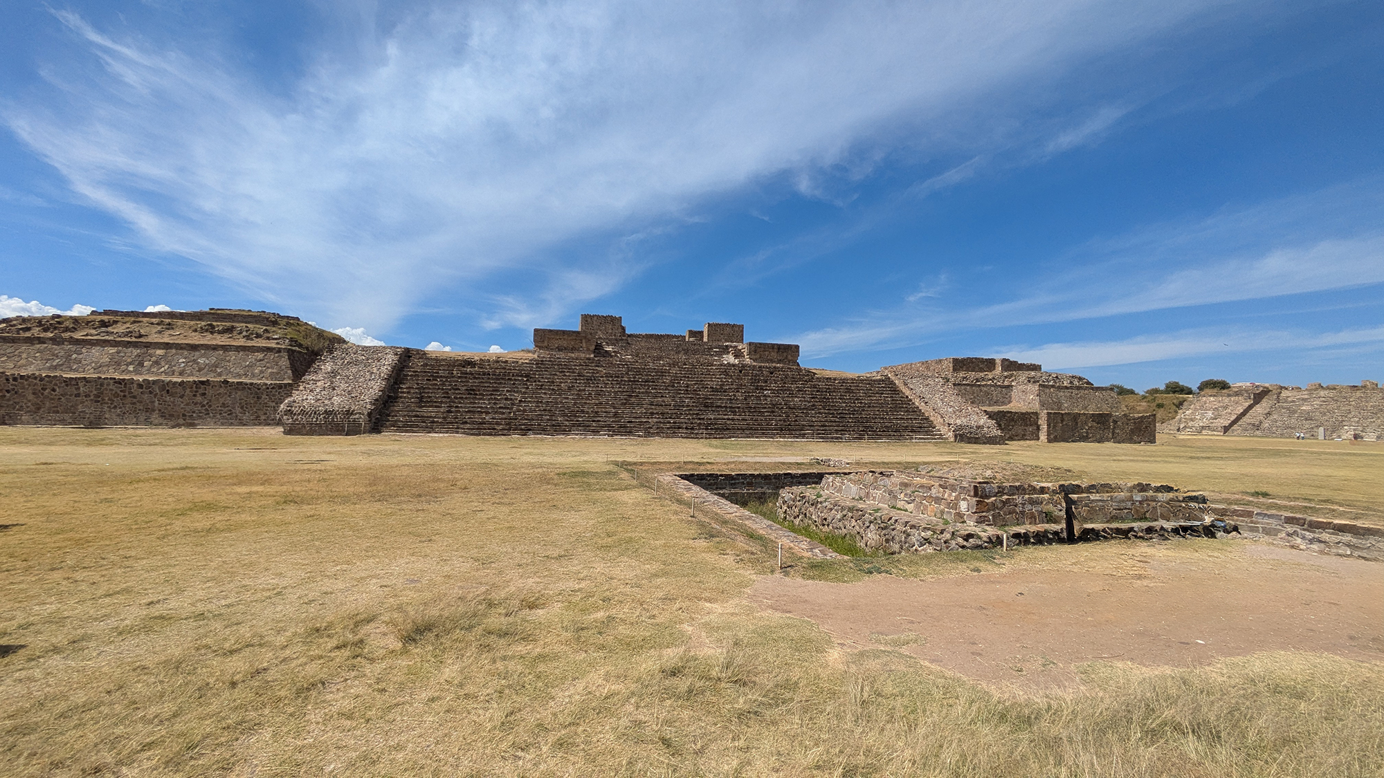
Building H is situated precisely at the geographic epicenter of Monte Albán’s Main Plaza, an expansive monumental esplanade measuring approximately 300 by 200 meters. Flanked by Building G to the north and Building I to the south, it constitutes the crucial central axis that divides the plaza into two massive functional halves. This deliberate placement provides incontrovertible evidence that the structure was engineered to serve as the primary organizational node within the site's urban planning.1
The visible morphology comprises a massive two-body stone platform supporting three distinct superstructures arranged intimately around an interior patio. This specific spatial configuration is vital, confirming that Building H was not merely an open public altar. Instead, it was a restricted compound designed to sequester internal activity at its summit. By establishing a privatized upper stratum elevated high above the general plaza, the architecture strictly regulated visibility, access, and ritual participation. Consequently, scholars frequently interpret Building H as the symbolic axis mundi of the monumental core—a physical materialization of state order in the heart of the city.3
Architecture and Construction
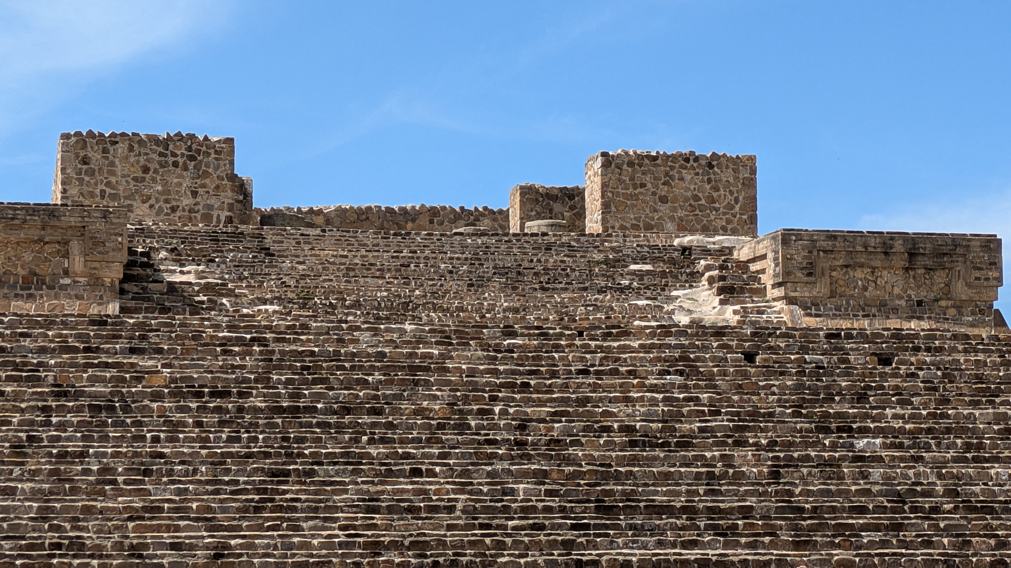
Architecturally, Building H employs the mature monumental lexicon of Classic-period Zapotec statecraft. The exposed edifice relies on a substantial two-tier lithic basamento that originally supported vast adobe superstructures, all sealed in burnished lime stucco. This structural form flawlessly aligns with the broader preferences of the Zapotec state for commanding, elevated sanctuaries within the ceremonial epicenter.1
The summit arrangement delineates three rectangular superstructures enclosing a central courtyard. The primary central structure asserted dominance, while the lateral buildings framed the upper plaza and exacerbated the sense of claustrophobic enclosure. This layout strongly corroborates the hypothesis that the compound was strictly designated for apex-elite utilization rather than public access.3
Stratigraphic and stylistic documentation emphasizes the utilization of structural columns and the implementation of the Zapotec double-scapular profile—a heavily localized architectural development related to the broader Mesoamerican talud-tablero aesthetic. This profile endowed the structure with immense visual gravity, structurally linking it to the overarching aesthetic vocabulary of Monte Albán’s zenith.3
The G-H-I Central Spine
To decode Building H, one must analyze it as the nucleus of the G-H-I group. Collectively, these conjoined structures generate the monumental spine that forcefully partitions the Main Plaza. Building H stands as the largest and most architecturally imposing member of this triad, and its centralized location transforms it into the physical pivot of the entire alignment.1
This macro-arrangement fundamentally dictated plaza functionality. The central spine did not merely divide geographic space; it actively engineered processional choreography, manipulated sightlines, and directed public perception. When observed from the commanding heights of the North Platform or South Platform, the G-H-I group manifests as a highly calculated intervention—one built to dictate how mass gatherings perceived the absolute center of power. Building H represents the zenith of Monte Albán’s "theatrical urbanism," where sovereign rulers and high priests were meticulously framed against monumental architecture, maximizing their visual impact upon the populace below.3
Subterranean Passages and Ritual Engineering
Among the most remarkable architectural features of Building H is its direct integration with a sophisticated subterranean passage network. Archaeological excavations have revealed that formal tunnels inextricably linked this central building to the Adoratorio located immediately to its east. This confirms that Building H must be evaluated not merely as surface architecture, but as a complex possessing a highly engineered, hidden ritual infrastructure beneath the plaza floor.16
These subterranean conduits are widely theorized to have functioned as theatrical mechanisms, permitting priests or elites to traverse unseen and "manifest" dramatically during state ceremonies. Regardless of the exact performative specifics, the irrefutable architectural reality is profound: Building H was embedded into an environment where subterranean movement was seamlessly synthesized with the most symbolically charged sector of the Main Plaza.
Further survey data indicates a vertical shaft or well-like aperture near the upper precinct of the structure. While its definitive function remains academically contested—ranging from hydraulic utility to astronomical alignment comparable to Building P—the current data lacks the necessary resolution to conclusively assign Building H a purely archaeoastronomical role on this feature alone.
Connection with the Adoratorio
Directly flanking the eastern façade of Building H lies the Adoratorio (the central sunken altar). This structural intimacy underscores why Building H must be analyzed as a node within a larger ritual ecosystem rather than an isolated monolith. The Adoratorio dominated the open expanse immediately preceding the building’s primary monumental stairway, acting as an extension of the same ceremonial field.6
The confirmed tunnel connection between these two monuments solidifies this interpretation. Building H was not just adjacent to the Adoratorio; it was structurally and functionally fused to it. In tandem, they forged a multi-layered ritual environment that masterfully exploited vertical elevation, subterranean concealment, and public exposure. This stands as one of the most masterful examples of choreographing sacred state action at Monte Albán.6
The Jade Bat Mask and the Eastern Ritual Zone
The universally recognized jade bat mask—an icon of Monte Albán's material culture—is frequently attributed loosely to Building H. However, rigorous archaeological context demands greater specificity: the mask was scientifically recovered from a sacrificial deposit explicitly located within the Adoratorio immediately east of the mound. It was not unearthed inside Building H proper, but rather within the highly charged ritual zone directly preceding it and connected via the subterranean network.7
This nuance is critical. It preserves rigorous stratigraphic accuracy while simultaneously illuminating Building H's significance. Because the Adoratorio and Building H operate as a unified ceremonial apparatus, the presence of the bat mask reinforces our comprehension of Building H’s eastern threshold as a primary locus for apex-status ritual—including human sacrifice, elite offerings, and intense underworld iconography.7
Burials and Funerary Context
Building H holds anomalous significance because monumental structures within the Main Plaza rarely yield the dense funerary assemblages characteristic of Monte Albán’s elite residential sectors (such as the North Platform). Nevertheless, comprehensive archaeological surveys have documented the presence of burials and compromised tombs directly associated with this central mass. This data confirms that Building H actively participated in elite commemorative and mortuary traditions alongside its public ceremonial duties.1
While the funerary record beneath Building H may lack the spectacular global fame of Tomb 7 or Tomb 104, its academic importance lies in its overarching spatial context. The true significance of these burials is found in the powerful convergence of geographic centrality, highly restricted access, subterranean integration, and proximity to the Adoratorio's sacrificial matrix.
Archaeological Research and Stratigraphic Depth
The fundamental structural layout of Building H was exposed and consolidated during the monumental, mid-twentieth-century Monte Albán campaigns directed by Dr. Alfonso Caso and Jorge R. Acosta. Their extensive interventions rendered the central spine legible, defining it as a core organizational feature of the Main Plaza while mapping the complex interplay of upper and subterranean architecture.
In the modern era, the Monte Albán Geophysical Archaeology Project utilized advanced Ground-Penetrating Radar (GPR) to detect massive, buried structures sprawling beneath the current Main Plaza. This research unequivocally demonstrated that significant Formative and early-phase architectural complexes lie entombed beneath the visible Classic-period monuments.4 Although the published data addresses the broader plaza stratigraphy, it definitively corroborates the hypothesis that the central G-H-I spine rests upon much older, foundational architecture. Consequently, Building H is not a static, single-phase monument; it possesses immense stratigraphic depth and a continuous, multi-century architectural biography.4
Interpretation: Administrative and Ceremonial Authority
Building H is most accurately interpreted as a hybridized elite node where ceremonial, administrative, and royal residential domains inextricably overlapped. Its cloistered summit architecture dictates extreme privacy and restricted access. Its absolute geographic centrality dictates supreme state importance. Its integration with tunnels and the sacrificial Adoratorio dictates advanced ritual engineering beyond mere habitation. Together, these vectors point to an edifice where sovereign authority was literally staged, rigidly managed, and physically materialized.3
While imposing rigid modern taxonomies—such as distinguishing between a "palace" and a "temple"—is fundamentally flawed when analyzing Zapotec urbanism, Building H clearly occupied the precise urban sector where divine ritual and civic governance shared the same footprint. It is the definitive structure for comprehending how the Zapotec state centralized power.
Site Context and Phenomenological Viewing Notes
To phenomenologically grasp the architectural intent of Building H, one must view it from the elevated vantage points of either the North Platform or the South Platform. From the plaza floor, the structure's immense scale can reduce it to an undifferentiated mass of masonry. However, from an elevated perspective, its true role as the organizational anchor of the G-H-I spine becomes overwhelmingly apparent.
While contemporary conservation protocols strictly prohibit access to the subterranean tunnels and the immediate summit, the principal monumental stairway and its direct dialogue with the Adoratorio remain highly legible in situ. For researchers and visitors alike, Building H serves as the ultimate physical proof that Monte Albán was an intensely planned ceremonial machine where human movement, visual sightlines, and state authority were deliberately engineered.
Scholarly References
- INAH. “Monte Albán.” Official institutional site description.
- UNESCO World Heritage Centre. “Historic Centre of Oaxaca and Archaeological Site of Monte Albán.”
- Marcus, Joyce, and Kent V. Flannery. (1996). Zapotec Civilization: How Urban Society Evolved in Mexico’s Oaxaca Valley. Thames & Hudson.
- Levine, Marc N., Hammerstedt, Scott W., Regnier, Amanda, and Badillo, Alex E. (2021). “Monte Alban’s Hidden Past: Buried Buildings and Sociopolitical Transformation.” Latin American Antiquity.
- Sullivan, Mary Ann. “Images of Monte Albán.” Useful site-level visual reference.
- Monte Albán Heritage Center. “The Adoratorio.” For the immediate ritual context east of Building H.
- Acosta, Jorge R. “El pectoral de jade de Monte Albán.” Arqueología Mexicana.