


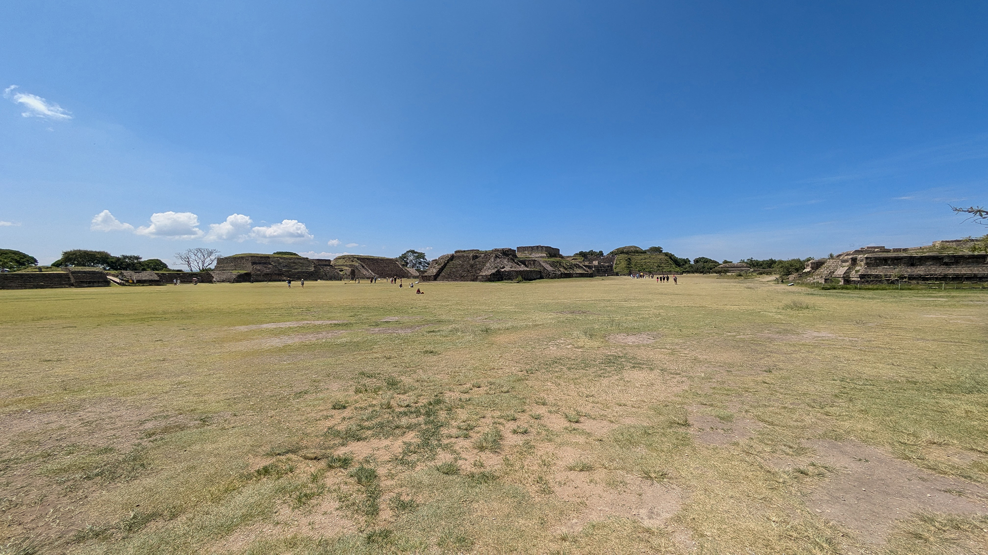
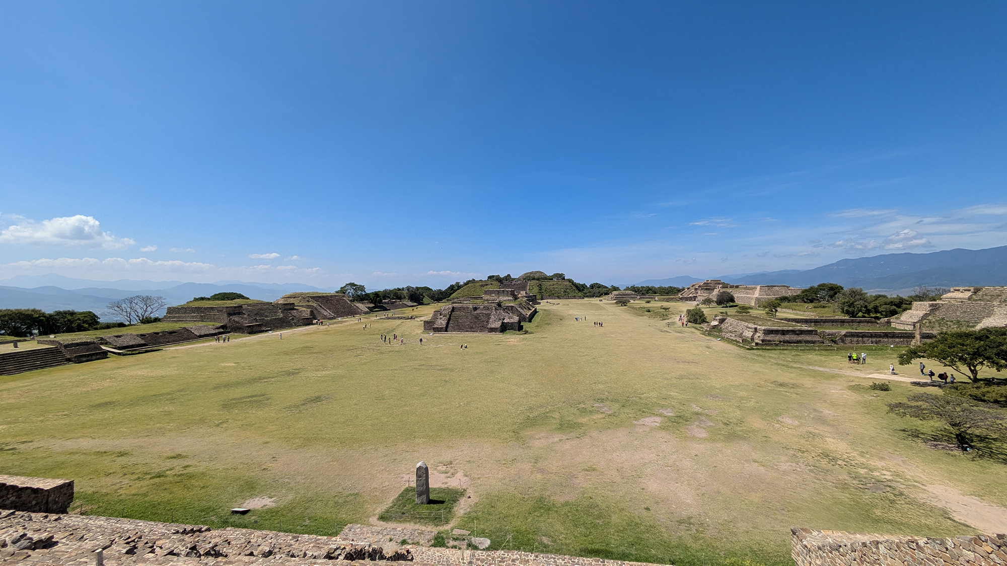
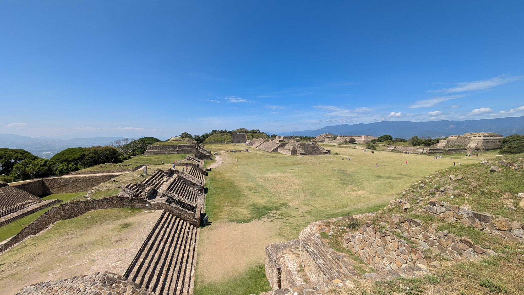
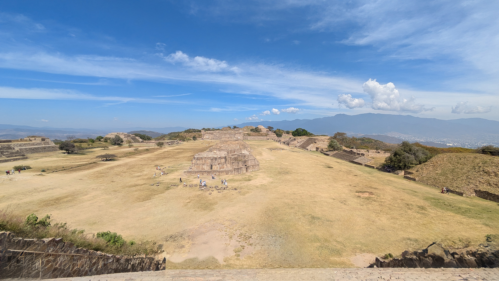
The Great Plaza constitutes the monumental civic-ceremonial core of Monte Albán, representing a profound feat of Formative-period landscape engineering. Created through the artificial leveling of the Jaguar Hill summit, this vast esplanade functioned as a "disembedded capital"—a neutral, engineered stage designed to unify the three arms of the Oaxaca Valley under a centralized Zapotec authority. Flanked by massive terminal platforms and containing a complex arrangement of oracular, administrative, and astronomical structures, the plaza served as the primary theater for state-level ritual, accommodate large-scale public congregations, and projecting the ideological hegemony of the Zapotec state for nearly a millennium.¹⁸
Geospatial Context and Architectural Layout
The Great Plaza is situated approximately 400 meters above the floor of the Oaxaca Valley on the terminal ridge of Jaguar Hill.⁸ The esplanade is delimited by the North Platform and the South Platform, both of which are accessed via monumental staircases designed to facilitate high-status visibility and ritual movement. To the east and west, the plaza is flanked by linear mounds that once supported restricted temples and elite palatial residences. This arrangement creates a highly controlled ceremonial concourse where access was dictated by social hierarchy.²³
A central longitudinal spine of mounds—including Buildings G, H, and I—bisects the esplanade, creating distinct fields of ritual action. The presence of the offset pentagonal Building J introduces an intentional asymmetry into the layout, serving as both a Conquest monument and a potential astronomical instrument.²
Dimensions and Cardinal Orientation
Modern surveying and INAH reports confirm the plaza’s almost rectangular geometry, spanning approximately 300 m (N–S) by 180–200 m (E–W).¹² While the majority of the monumental core adheres strictly to a cardinal grid, the deliberate 15-degree offset of Building J has long been a subject of archaeoastronomical debate. Research by Anthony Aveni suggests this orientation was calibrated for the zenith passage of the sun and the observation of stellar rising points, marking the plaza as a chronometric environment.⁵
Surface Engineering and Ritual Staging
The Great Plaza's current grassy appearance belies its original engineering. Excavations reveal that the Zapotecs applied a thick layer of stucco plaster over the artificially leveled bedrock, creating a reflective, sterile arena for state spectacles. This surface effectively dramatized the contrast between the unrefined mountain landscape and the ordered, "civilized" world of the Zapotec capital. Architectural sightlines were meticulously aligned to emphasize temple façades, ensuring that any ritual performed within the plaza could be witnessed by the 10,000 to 15,000 participants who could congregate here during festivals.¹³
Militarism and the Gallery of Danzantes
The western perimeter of the plaza precinct houses the Gallery of the Danzantes (Building L). This corpus of over 300 carved volcanic tuff slabs features depictions of contorted, mutilated male figures, accompanied by early Zapotec hieroglyphs. While 19th-century interpretations labeled these as "dancers," modern militaristic paradigms identify them as high-status captives and sacrificial victims. By permanently embedding these images of violence into the foundation of The Great Plaza, the state utilized the esplanade as a visual ledger of conquest and regional dominance.³⁶
Building J and the Conquest Narrative
Occupying a unique position in the plaza’s southern field, Building J stands as a testament to the expansionist Zapotec state. Its exterior walls incorporate dozens of inscribed panels known as the Conquest Slabs. These panels utilize place-glyphs—inverted heads topped with toponymic markers—to record the administrative subjugation of regional towns. The placement of this monument within the open plaza ensured that the record of state victories remained a permanent fixture of public memory.⁴⁵
Geophysical Prospecting and Buried Structures
While the visible architecture reflects the site's Classic-period apogee, recent ground-penetrating radar (GPR) and gradiometry studies have revealed a "Hidden Monte Albán" beneath the current plaza surface. Research led by Marc Levine and colleagues (2021) identified square structural anomalies dating to the Danibaan and Nisa phases (500 BCE–100 CE). These findings indicate that the Great Plaza underwent multiple cycles of structural erasure and rebuilding, transitioning from an early village cluster to the expansive, unified esplanade visible today.⁷⁹
Institutional Visiting Protocol
To fully comprehend the ceremonial choreography of the site, visitors are encouraged to view the plaza from the summit of the North Platform, which provides the authoritative panoramic perspective. Standard professional routes follow a clockwise circuit: ascending the South Platform to observe the central mounds (including Building J), traversing the eastern ballcourt precinct, and concluding at the western complexes (System IV and the Danzantes Gallery). Field researchers are reminded that the site closes at 16:30 and appropriate archaeological preservation etiquette must be maintained across the stucco-sensitive terrain.
Scholarly References & Primary Sources
- INAH. "Monte Albán: Official Institutional Site Profile." (Technical data on leveling and capacity).
- UNESCO World Heritage Centre. "Historic Centre of Oaxaca and Monte Albán." (UNESCO Property #415).
- Metropolitan Museum of Art. "Monte Albán: Sacred Architecture and the Gran Plaza."
- Marcus, Joyce. (1980). "Zapotec Writing." Scientific American. (Analysis of Conquest Slabs on Building J).
- Aveni, Anthony F. (1972). "Mound J, Monte Albán: Possible Astronomical Orientation." American Antiquity, 37(4).
- Orr, Heather S. (1993). "The Danzantes of Building L at Monte Albán." FAMSI Research Report.
- Archaeology Magazine. (2020). "Square Structure Detected Beneath the Main Plaza of Monte Albán."
- Marcus, Joyce, & Flannery, Kent V. (1996). Zapotec Civilization: How Urban Society Evolved in Mexico’s Oaxaca Valley. Thames & Hudson.
- Levine, M. N., et al. (2021). "Monte Albán’s Hidden Past: Buried Buildings and Sociopolitical Transformation." Latin American Antiquity.
